- Hawksbill
Crag Geocache
- Northwest
Arkansas
|
-
- Driving
Northwest Arkansas
|
|
- Larry and
I have always enjoyed exploring northwest
Arkansas. Larry was born in the area near
Leslie, and we were married outside Eureka
Springs at the well-known Thorne Crowne
Chapel - - the 'glass chapel in the
woods.' We first hiked the Hawksbill Crag
Trail several years ago and always planned
to return. This time, we thought placing a
geocache was a perfect excuse for a winter
hike (Note - - most of these are new
photos taken on a return visit, September
2002). With clear skies and a
temperature of 65 degrees F, it seemed
more like spring than January.
-
- To get to
the hike and geocache, drive down Highway
43 from Harrison and continue through
Ponca through the Boxley Valley area. Head
south on Highway 21 for 1.2 miles. Just
before the bridge across the Buffalo
River, turn right onto the gravel road
called Cave Mountain Road. This road
starts with a curving drive up the steep
side of a mountain. Fun! You don't need a
four-wheel drive, but the road can get
bumpy.
|
The hiking area is part of the Ozark National Forest
near the Buffalo River. Drive 6 miles (from the turn
off Highway 21) to the Upper Buffalo Wilderness Area
parking lot on the right. As a reference, you'll pass
the Cave Mountain Church and cemetery on the right at
5.4 miles. -
- Hiking
Hawksbill Crag Trail
- The next
phase of your adventure leads you down a
well-marked trailhead (N 35 54 100 W 93 27
617). Cross the street from the parking
lot and you'll see the trailhead. The hike
from here is about 3 miles "out and back."
A few feet down the trail, you'll find a
sign-in sheet for wilderness hikers.
-
- After a
few switchbacks you'll come to the first
of many tiny stream crossings. They were
flowing during the winter, but may dry up
in the summer. The light green and blue
lichens and mosses could really be seen
without the undergrowth, bushes, and trees
that fill the landscape in the summer
months.
|
|
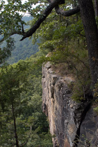
- At about a mile,
you'll cross a small creek and see a fork in the road.
Either way works. If you go to the left, you head
uphill and walk across a ridge and onto the bluffs
area. If you walk to your right, you'll get to see a
couple waterfalls along the trail. The hike continues
around the crest of the cliffs. If you've got small
children, you might consider the woods hike rather
than the cliffs. Either way and you'll end up at the
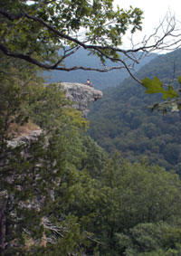
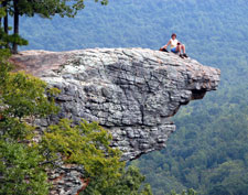
Hawksbill Crag overlook. It's also known as Whitaker's
Point. This huge rock outcrop extends over the edge of
the bluff. The photograph above was taken from a
viewpoint just before reaching Hawksbill Crag. You may
have seen the photo before. Similar shots are on the
cover of several Arkansas hiking books and
postcards.
-
When you get to the
overlook, spend some time enjoying the great view of the
Whitaker Creek Valley. Because we placed the cache on a
winter weekday, the area was quiet except for a couple of
campers. You could hear the wind rustle in the dried
leaves of the oak trees. The smell of pines and cedars
was everywhere. Be sure to keep your eye out for
wildlife. We saw deer along the road on the way to the
trail. Cliff swallows and red-headed woodpeckers were a
couple of the birds we saw. In addition, we saw lots of
small creatures such as spiders, mice, and squirrels - -
and this was on a warm January day.
-

|
- Placing
the Geocache
- Since
this is a popular hike, we decided not to
place the cache right at the overlook.
Instead, we did some exploring and found a
great lookout point away from the
potential crowds.
-
- We got
out our GPS device and checked the
location. The cache is at N 35 53 475 W 93
26 389. Since it's winter, the GPS had no
trouble reading in the woods. However, we
envision this might be a problem in the
summer, so we also did a reading at the
Hawksbill Crag Overlook. The waypoint for
that is N 35 53 457 W 93 26
426.
|
The cache contains a log book, trashbags, a camera,
and a travel bug named Marti
Maverick. The
treasures include 2 stuffed beanies (chicken &
iguana), hacky sack, 3 toy cars, 1 windup bug, 2
plastic frogs, 1 snake ball, 1 pair of dice, 2 key
rings (measuring tape & car), 3 gems (turtle,
alligator, canoe), and a climbing clip.-
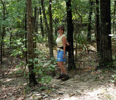
- Don't read this
section if you don't want to learn the cache location
hints. You'll have to go on down the trail, past the
crag, less than 100 paces. The cache is located
between the trail and the bluff, close to the edge. We
found a great spot between two boulders (One of them
is very large) under a fallen log. In the picture
below, Larry is placing some rocks around the cache to
keep it well-hidden from everyone but
geocachers.
-
- Exploring
the Geocache
- We have a
few suggestions if you want to visit the
geocache.
-
- 1) This
is a great area for picnics. Be sure to
bring a lunch to eat at the Hawksbill Crag
overlook.
-
- 2) You
might also try overnight tent camping in
the area. There are a couple of campsites
up the hill from Hawksbill Crag overlook.
Register for overnight and observe the
regulations for campfires.
-
- 3) There
are a number of places where the trail
crosses tiny creeks... it can get slippery
in winter and spring. Be careful.
-
- 4) Also
be careful not to get too close to the
bluffs, it can be windy and
slippery.
-
- 5) The
trail starts out downhill, so remember
that you have to return back uphill. It's
pretty easy going, but keep it in mind
when you're planning.
|
|
|
- We hope
you enjoy our second geocache!
:-)
-
- If you're
interested in checking out other area
hikes, check out the Ozark
Mountain Hiking
Page.
-
- Go to the
Hawksbill
Crag
page at geocaching.com for additional
details and logs.
|
-
-
Created by Annette
Lamb
and
Larry Johnson,
01/02.
|


