- Smith
Mesa Geocache
- Smith
Mesa, Southwest Utah
|
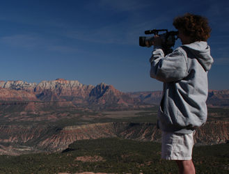
 - Smith
Mesa - View to the
North
|
- Exploring
Southwest Utah
- As
full-time RVers we've spent winters in
both Arizona and Southern California. The
winter of 2002-03 we decided to stay at
the Zion
River RV
Resort
in Virgin, Utah.
-
- Located
just a few miles from Zion National Park,
this area has mild winters and endless
recreational opportunities. Miles and
miles of gravel and 4 wheel drive roads
can be found in every direction. One of
our favorite drives starts in Virgin, goes
to the top of Hurricane Mesa, along Smith
Mesa, and back to Virgin on Kolb
Road.
-
-
-
|
-
- From the top of Smith
Mesa, you can see mountains in every direction. To the
east are the mountains of Zion National Park
(below).
-
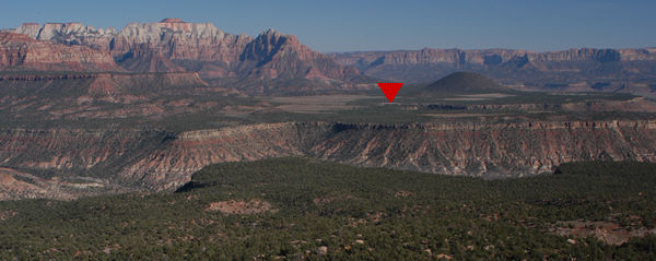
- We decided to set two
caches in this area. One on Smith Mesa and the other
on Dalton Wash. The Dalton Wash cache is marked with a
red arrow below.
-
-
-
- Exploring
Smith Mesa Road
- Begin
your adventure just west of Virgin, Utah
on Highway 9. At Mile Marker 17, turn
north on Mesa Road (1250 West). This
intersection is at (N 37 12 330 W 113 12
620). Drive 3.4 miles on a mixture of
paved-gravel road. The road takes you on
an exciting trip up the side of the mesa.
Watch for other vehicles on the tight
corners!
-
- After 3.4
miles, you'll reach a fork in the road.
Left/straight is a dead end. You want to
go right (N 37 14 469 W 113 12 486). This
is Smith Mesa road, but it's not marked.
You'll leave the blacktop road and enter a
primitive gravel road. This road is fine
for cars. Go 2.8 more miles and you'll see
a turnoff to your right (N37 15 909 W 113
10 646). If you have a car, park here. If
you have a high clearance 4 wheel drive,
you may want to continue up the hill.
However it's only .14 miles to the cache
and you're really better off
walking.
-
-
|
 - Smith
Mesa
Viewpoint
|
|
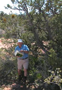
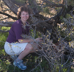
- Placing
the Geocache
- We found
a great location where you can see 360
degrees including mountains on all sides!
We got out our GPS device and checked the
location. The cache is at N 37 15 781 W
113 10 645.
-
- The tan
ammo box cache contains a log book,
trashbags, and a camera, bookmarks, and a
traveling "Where's
George"
dollar. The treasures include painted
rocks and lots of other
goodies.
-
- Don't
read this section if you don't want to
learn the cache location
hints.
-
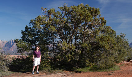
- We placed
the cache close to the best viewpoint. The
cache is located at the base of a juniper
tree near a rock overlook (photo left).
|
- In the picture below,
you can see that the cache is covered with rocks and
branches. There are some thorny bushes near the cache.
Walk on the rocks to avoid them.
-
 -
- Exploring
the Geocache
- We have a few
suggestions if you want to visit the geocache.
-
- 1) Take your time
along the Mesa scenic drive. If you've got time,
continue past the geocache and you'll eventually
connect with Kolb road going back to Virgin. There are
very few cars on the road, so come prepared for a
great time. However also come prepared for
emergencies.
-
- 2) There are tons of
great places to camp and hike in the BLM lands. Bring
your tent and spend the night along the drive. If
you're RVing stay at the Zion
River RV Resort
in Virgin UT.
-
- 3) The hike would be
best in the Fall or Spring. The road is impassible in
wet or snowy winter weather and it's hot in the
summer. Watch out for rattlesnakes in the summer.
Also, watch for sharp bushes and spiny
cacti.
-
- We hope you enjoy our
fourth geocache! :-)
-
- Go to the
Smith
Mesa page at
geocaching.com for additional details and
logs.
-
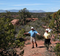
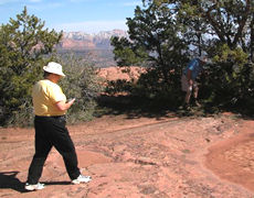
- Update from
Smith Mesa
- Here are pictures of
our first visitors to the geocache. Joe, Sue, Jim, and
Sue Ann were so excited about visiting the geocache
that we gave them the waypoints before even uploading
to the geocaching website. They had a great
time.
-
-
-
-
-
Created by Annette
Lamb
and
Larry Johnson,
4/03.
|