- Carlsbad
Caverns and Guadalupe Mountains
-
- The Trip to Carlsbad
- We headed west from Alpine through Marfa, then north
on highway 90. It was very quiet with very few cars,
dried-out ranches far apart, and a scattering of cows now
and then. Even the town of Valentine looked like it had
seen more prosperous days with empty storefronts, vacant
houses and abandoned equipment.
-
|
|
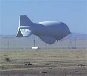
- Before reaching Valentine, we saw a small
airfield with a tethered blimp. We could see
the object for a few miles, and in this
sparce landscape it attracted our puzzled
attention. Advertising? When we got closer,
we saw that it was a plain white, kinda short
and stubby. We later learned that it was 'Fat
Albert,' a tethered radar blimp that is used
by the U.S. Government to search for
airbourne drug runners.
-
|
It was really windy, so driving involved staying alert
to some pretty stiff gusts. We were gradually swinging to
the north on our way past Guadalupe Mountains to
Carlsbad, NM. The wind began giving us problems. We could
stay on the road O.K, even in the narrow and rough
sections. But it was catching our awnings and unrolling
them. We stopped first for one side, then the other. It
was quite a trick to open an awning into the wind, and
get it to reroll properly. The wind was now a steady
blow, with sharp unpredictable gusts. We stopped again
and this time reinforced the awnings with a couple bungee
straps. As we finished the task, a state patrol officer
stopped to check with us. He suggested that we might want
to 'sit it out for a few hours' to see if the wind dies
down. He mentioned that down the road a semi-trailer had
just been blown onto a guard rail. We cautiously headed
on up the road.-
-
- We reached highway 52 and turned northeast toward
Carlsbad. We were greeted by permanently mounted warning
signs for high wind areas. We drove into the burg of
White City, located on the west end of the national park
entrance. We check into the campground and quickly
learned that all the hotels, cabins, the campgrounds, all
the shops and stores were owned by one person. You
guessed it, a Mr. White. Our campground was stark, very
few amenities but we had full-hookup and faced the
mountain.
-
- Carlsbad Caverns
- Carlsbad Caverns
National Park is located in the Guadalupe Mountains
in southeastern New Mexico. Early settlers called the
caverns Bat Cave because of all the bats. A million
Mexican freetail bats live in the cavern. In the early
1900s the bat droppings or guano was mined as a valuable
nitrate-rich fertilizer. Jim White was a young miner and
enjoyed exploring the caves in addition to his job at the
mine. His interest in the caves lead others to become
interested in preserving this natural wonder.
-
- In 1923 the caverns were named a national monument
and in 1930 the area became a national park because of
its natural beauty. One of the parks major attractions is
the Bat Flight that occurs every evening in the summer.
At dusk, hundreds of thousands of bats fly from the
caverns in search of food. Since we explored the caves in
winter, the bats were "vacationing" in a warmer
climate.
-
- Our exploration began at the Visitor Center where we
examined the wide range of activities available at the
park. We decided to enter the Natural Entrance of the
cavern and take the mile long hike down into the Big
Room. After purchasing our tickets and turning on our
"audio tour" headsets, we started down a short nature
trail to the cave entrance. The Natural Entrance is
described as a "strenuous" hike, but we decided that any
trail that's all downhill can't be that tough! The paved
walkway began with a series of switchbacks leading into a
dark fairyland of beautiful stalactite and stalagmite
formations.
-
- The Guadalupe Mountains were originally an organic
reef at the edge of a great warm sea. Over time the reef
was covered with sediment and began to develop fractures.
Carlsbad Caverns were formed by the dissolving action of
underground water in the cracks made in the limestone.
Dramatic earth movements caused the mountains to lift up
and the water in the cave was replaced by air. Today,
melting snow and rainwater continue to leave droplets of
water that dry and leave behind a mineral such as
calcite. These mineral deposits form stalactites,
stalagmites, columns, popcorn, and other interesting
formations.
-
- Although the surface temperature was cool in winter
and hot in summer, the caverns remain a constant 56F
degrees. We found jeans and a light jacket the perfect
attire. At the end of the Natural Entrance trail, we
found restrooms, a gift shop, and lunchroom. Although we
wondered whether these modern conveniences were
appropriate in a place of such natural beauty, the
restrooms and drinking water were a welcome sight. We
asked a ranger about the issue of conveniences over
preservation and she pointed out that the modern plumbing
was a great improvement over the old chemical toilets
that caused both smell and underground air pollution.
With hundreds of thousands of people using the caves each
year the facilities are essential.
-
- As we entered The Big Room we wondered whether we
might get bored with another mile of cave. However there
with an interesting formation around every corner and we
didn't have time to get bored. We found the following
interested facts:
- Stalactites are formed from water dripping from a
ceiling.
- Stalagmites are created from water falling on the
floor of the cave.
- Soda straws are thin, hollow stalactites.
- Draperies are formed where water dripped down a
slanted ceiling.
- When a stalactite and stalagmite are joined together,
they form a column.
- Popcorn is formed when water evaporates and leaves
behind a mineral deposit.
- Cave pearls are created as layers of calcite form
around a tiny object such as a grain of sand.
-

|
- Guadalupe Mountains
- Our next stop was Guadalupe
Mountains National Park. The Guadalupe
Mountains are part of an ancient marine reef
that formed 250 million years ago when this
area was part of a tropical ocean. The
ancient reef towers over the landscape.
-
- We enjoyed a 4.6 mile round trip hike in
McKittrick Canyon to Pratt Lodge. Lined with
maple, walnut, ash, and chokecherry trees, it
was beautiful in the spring. We'll have to
come back and see the colors in the fall.
This was an easy hike along a beautiful sandy
creek.
|
|
We enjoyed reading about the stage coach
trail that went through the park. At The Pinery
there are ruins of a stagecoach station on the
Butterfield overland mail route from the mid
1800s. The route varied through history, but the
remains of this stop can still be seen.
We also visited the visitor center as we
traveled south out of the park. It was windy
again as we drove along the mountains, then
headed west toward El Paso.
|

|
Created by
Annette
Lamb and
Larry
Johnson,
7/01.- Updated 5/02.
-

- Return
to Trip Page
|


