- Lassen
Volcanic National Park
- Days
3-4
-
- Lassen Peak
- Our challenge for this trip was the hike
to Lassen Peak. The five-mile round hike to
the top of this 10,457 foot peak is
considered "mountain climbing" but does not
require any technical climbing skills.
Although the trail is open in May, it's not
recommended for hiking until July because of
the deep snow pack. This year a lighter than
normal snow accumulation made a May ascent
easier, although we mushed through snow about
half the time making the hike very
tiring.
-
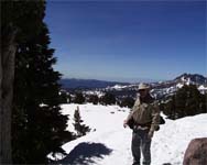
- We didn't get up as early as we had
hoped, but we got to the base of the mountain
by 10:45 a.m. and began our hike. The first
four people we saw going up the trail were
carrying ice picks. Three people were dressed
in snow boots, gaters, jackets, gloves,
packs, and poles. Needless to say, we were
intimidated as we looked up at the
snow-packed trail. We were dressed in long
sleeve shirts, pants, and carried our
jackets. As we put on our hiking boots, we
talked to two hikers who had just returned
from the top. They said that we might get a
little wet, but that we were dressed fine. We
felt a little more confident and decided to
give it a try. The hiking guide said the
trail would be steep and strenuous, but we
thought we could handle the 2000 foot ascent.
The key to a strenuous hike in high altitude
is regular rest and lots of water. We were
already acclimated to a 5000 foot altitude
from our time in Reno.
-
|
|
The trail began with a warning sign indicating that it
would be snow and ice covered, duh! Snow covered
everything as far as we could see. Within a few hundred
feet up the trail, we stopped to talk with a park worker
who was working on the trail. He was attempting to
reroute hikers to the original path as indicated by pink
flags in the snow. As we proceeded through a meadow area
we talked to another park worker. Soon we found ourselves
in endless switchbacks that slowly made progress up the
mountain. At first the snow cover was only interrupted by
a few pine trees and large rocks. As we made our way
higher, we left the tree line and saw more exposed, bare
ridges. It was windy and cold on one side of the
mountain, but when we switched back to the other side it
became calm. The views were spectacular. As we caught our
breaths, we enjoyed gazing at the ice covered, blue lakes
of Helen and caught an occasional glimpse of Emerald Lake
in the distance. In the other direction, we could see
Crumbaugh Lake. In all directions we saw magnificent
mountains.-
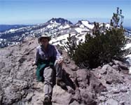
- About half way up, we reached the first interpretive
sign talking about the origins of the mountain. As we
looked up, we discovered what we thought was the top of
the mountain. It was still a long, long, way up. We were
already tired and realized we had a long way to go. The
switchbacks began to get shorter and steeper. We stopped
for a rest on the calm side of every switchback and
speculated on which mountain in the distance might be
Mount Shasta. We had been told that on a clear day you
could see this magnificent mountain in the distance. The
mountains all looked somewhat the same to us.
-
|
|
- By now the trail snow was almost gone
from the trail, but we could see the glacial
snow on the side of the mountain. The trail
became more rocky and we had to watch our
footing. We were encouraged by meeting a few
people coming down who said we were getting
close and that Mount Shasta was visible.
|
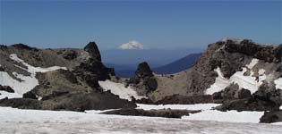
- After a final traverse through some glacial snow and
a few more switchbacks, we reached the top. Wow!
Mount
Shasta was huge and wasn't visible until we crested
the mountain top. There was no mistaking this magnificent
mountain. The other mountains were dwarfed by comparison.
The view of this snow capped peak was well-worth the
huffing, puffing, and damp feet.
-
- We talked to a group at the top from Chico who were
using this climb as practice for Mount Shasta. We let
them know that this "was the climb" for us. Mount Shasta
and the other 14ers will have to wait. Rather than
heading down, we decided to try the hike to the
"jumbles." This rock formation was a brief hike across
the snow to some huge boulders and a cone-shaped radio
transmitter. The snow was no problem, the boulders were.
Only a snow-covered ledge stood between the boulders and
a sheer cliff. With no climbing gear, we took our time
and clung to the rock face. When we reached the top, we
were rewarded with an even better view of Mount Shasta,
as well as the devastated area from the 1915 eruption.
The mountain was unusually calm and sunny. We stopped for
some yogurt and 'nilla wafers before beginning our
descent down the mountain.
-
- As we headed from the jumbles back to the peak, we
saw a hiker putting on his snow skies. He and a companion
on a snowboard were planning to sail down the mountain
the fast way. We decided the trail was the best route for
us.
-
- The trip down the mountain was fun! We were able to
smile and say hi to everyone trudging up the mountain.
Boy, it's great to be able to breathe. The melting snow
and loose gravel presented a bit of a challenge as we
flew down the mountain. We both slipped a few times
causing our pants to become a little wet and our socks
and hiking books to become saturated. By the time we got
to the bottom, Larry was able to ring water out of his
socks.
-
- As we celebrated our success, we began to realize
that our muscles were tired and our faces were very red.
Even with hats and sunscreen, the hot sun reflected off
the snow causing sunburns. After changing into shorts and
fresh socks, we were ready to head home to a hardy meal
of chicken stew in our Dutch oven.
-
-
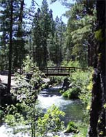
- Hat Creek
- The goal for our final day was
relaxation... no hikes, no climbs, no
schedules. After sleeping late and eating a
brunch of bacon and pancakes, we headed down
the road to the Hat Creek Campground where we
found a quiet place in the shade to
relax.
-
- We read, sketched, snoozed, and generally
goofed off. This was a major achievement
since we spend so much time working. Other
than a brief setback when Larry did some
brainstorming for an article based on his
dissertation, the day was spent relaxing and
recovering from our vacation.
-
- Read More About It
|
|
Created by Annette
Lamb and
Larry
Johnson,
7/01.
- Updated 5/01.
 - Return
to Trip Page
|


