- Death
Valley
-
- Driving to Death
Valley
- We planned a full-day trip to Death
Valley National Park, so we decided to
head out early. We drove north through
Pahrump and into the small mining community
of Beatty. After a brief stop at the
information center and bought a thin book on
the local ghost town, then headed west into
Rhyolite. We walked among the remains of the
bank, jail, and other buildings of this once
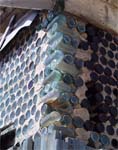
thriving mining community. The highlight of
the town was a small house made out of glass
bottles known as the "bottle house."
-
- We continued down highway 374 toward the
park. Along the way, we passed a turnoff to
Titus Canyon and decided to save that for
another time. Instead we continued into the
heart of the park, past the sand dunes into
the area called Stovepipe Wells Village.
|
|
Mosaic Canyon- Our guidebooks all said that the hike in Mosaic
Canyon is one of the best in the park. The gravel road
leading to the parking lot is located just past the
Stovepipe Wells Village. The 3-4 mile round trip hike was
magnificent. The trail starts off wide and narrows into a
high-walled canyon of colorful slickrock and polished
marble. The rock formations were created when rock
fragments became cemented together into what's called a
mosaic breccia. Many people turn around when the canyon
becomes steep, but this is where we thought it got
interesting. We hiked until we reached a dry waterfall
that we couldn't climb without ropes.
-
-
- Furnace Creek Area
- The Furnace Creek Area of the park is south down
highway 190. We stopped at the Harmony Borax Works
Interpretive Trail and enjoyed the history of the area
including the huge borax wagons. We continued to the
visitor center for more information. It was getting late,
so we spent a few minutes at the smelly Badwater stop
(lowest elevation in the US at -282 feet) before heading
back to Las Vegas. We decided that we needed to bring the
RV back next time and spend a few more days
exploring.
-
-
Created by
Annette
Lamb and
Larry
Johnson,
7/01.
- Updated 5/02.
-

- Return
to Trip Page
|


