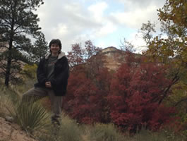
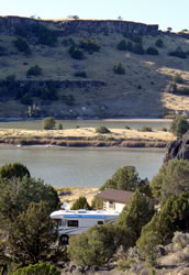
Lamb Update: October 2003 Massacre Rocks State Park The first of October we moved from North Folk, ID to Massacre Rocks State Park, ID. This state park is on the Oregon Trail. We hiked and viewed the Oregon Trail ruts, Register Rock, and the site of Shoshone Indian and Pioneer skirmishes. In the photo (below left), Annette is standing on the ruts of the Oregon and California trails. Below right is view of the Snake River out our front window:
Although we loved the campground at the Massacre Rocks State Park, we were frustrated by their construction. The water and electricity weren't working most of the time because of construction, so we had to dry camp. On the other hand, it was quiet and the views were great. They promise all the construction will be done before we come through next time.
From Massacre Rocks State Park, we headed to Salt Lake City. Annette's sister Arrion flew in for a conference so we had a chance enjoy some restaurants and shopping. After dropping Harvey RV off to have a new satellite dish installed, we flew to Anaheim, California for the annual AECT conference. While we were there fires extended from the Mexican border to northeast of Los Angeles. The smoke from the wildfires was bad even in the hotel. Soot and ash covered the car. As we got ready to board our plane for Salt Lake City we were informed that the airport was closed. They had to evaculate the air traffic control station near San Diego because of the fire. After fire delays, hours on the runway, and maintenance delays we finally arrived back in Salt Lake City.
|
AECT in California In late October, we flew from Salt Lake City, Utah to Orange County, California for the Association for Educational Communication and Technology Conference. The conference took place at the height of the fall fires. Even though the fires were miles away, we could see ash falling at our hotel. Many people including many of our fellow conference participants were stranded at the Orange County airport when the air traffic control tower for southern California was shut down for a few hours because of the fire.
|
Our New Baby We picked up our new twins: the DirectTV dish and the Datastorm F3 dish. Unfortunately, when we arrived in Virgin UT, our Datastorm wouldn't connect to the Internet. After a couple days of frustration, we traveled back to Salt Lake where they were able to fix the problem. Although we ran into a little snow, the trip was worth it. 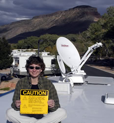
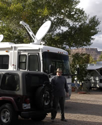
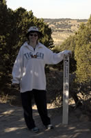
After a few more adjustments we finally have a new high speed Internet system with enough power for our deskop computers and wireless laptops. In the picture (above left), Annette is sitting on the roof of the RV holding our dish caution sign. In the picture (above right), Larry's standing between Wrang the Jeep and Harvey RV with the new dishes on the roof. Harvey RV will be parked for the winter in Virgin UT a few miles from Zion National Park. It's the same spot where we stayed last year. This is the first time we've gone back to the same place two years in a row.
|
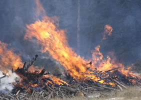
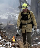
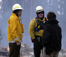
There are dozens of cool places to explore in Southern Utah. We only took time out to visit a few last year. One of the places we wanted to visit was Cedar Breaks National Monument. Since it closes in mid November because of snow, we knew that it we wouldn't have much time to visit. After a couple small snows, we decided we better take some time off for a day trip. We left the campground in Virgin and traveled north on the gravel Kolob Road for 45 miles to highway 14. As we headed into the mountains we went from fall weather and colorful trees to snow covered mountains and bare trees. Our campground is at 3500 feet and Cedar Breaks is at 10,000 feet. We had hoped to take pictures at Cedar Breaks, but the weather became foggy. Instead we took pictures of National Park fire control personnel burning clusters of wood as part of their fire prevention program. We stopped and had an interesting conversation about the role of fires in National Parks.
|
|
Zion National Park We continued our trip along Highway 14 and turned south at Navajo Lake along the North Fork of the Virgin River. This gravel and dirt road took us down to the east entrance of Zion National Park. We took lots of great pictures of the park with the beautiful yellow and red leaves. Our trip concluded with a drive back to the campground. It was a great 6 hour loop trip! |
Go to Lamb Menu |

 The
campground was filled with rabbits. In the evening and early morning
they appeared from under bushes everywhere. The area was great for hiking.
We took lots of pictures from the top of the area hills. In the picture
on the right you can see the RV. We loved the park because no one was
around. At times, we were the only ones in the park.
The
campground was filled with rabbits. In the evening and early morning
they appeared from under bushes everywhere. The area was great for hiking.
We took lots of pictures from the top of the area hills. In the picture
on the right you can see the RV. We loved the park because no one was
around. At times, we were the only ones in the park.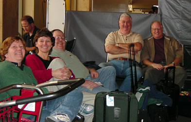
 Fires
at Cedar Breaks
Fires
at Cedar Breaks