Update:
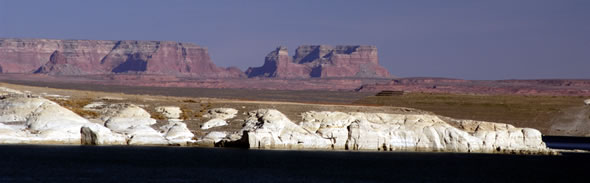
March 2004 We arrived in Page, Arizona on March 15th after spending the winter near Zion National Park. We camped at the Wahweap Campground overlooking Lake Powell. We were told that the lake was at the lowest water level in history, over 100 feet below its highest pool level. Water would normally cover the white rocky areas in the photograph below.
Although there were many choices for sight seeing, we decided to take a short hike to Horseshoe Bend Overlook, visit the dam, and photograph Antelope Canyon.
|
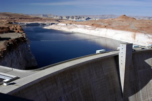
The Carl Hayden visitor center is has information about the lake, dam, Grand Canyon, and the Glen Canyon National Recreation Area. The Glen Canyon Dam was built in the early 1960s and created Lake Powell. Security was high at the dam with metal detectors and officers guarding the entrance to the building.
|
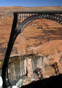
We were told that since the lake water level was at a 30-year low, there are historical areas such as petroglyphs that are now above water. Unfortunately we didn't have time to explore any other these areas. Instead, we chose the short hike to Horseshoe Bend. The photograph on the left shows the Navajo Bridge. Rather than driving across the dam, people cross the river using this nearby bridge. |
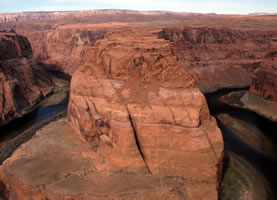
Horseshoe Bend Horseshoe Bend is a deep, U-shaped bend of the Colorado River just south of the Glen Canyon dam. We hiked a half-mile up a sandy hill and along a rocky path to the magnificant overlook shown in the photograph below.
|
Go to Lamb & Johnson
Menu
|
 Glen
Canyon National Recreation Area
Glen
Canyon National Recreation Area