- The Big
Island:
- Hawaii
Volcanoes National Park
- Our adventure began on "The Big
Island." The names of the islands are a
little strange. The state is named Hawaii,
but the largest island is also called
Hawaii. To avoid confusion, they call this
island "The Big Island". Although it's
called "big", it does not have the most
population and is not where the capital
city (Honolulu) is located.
-
- We flew from Phoenix through Dallas
and Honolulu to Hilo, Hawaii. Not the most
direct route, but a smooth flight.
Arriving at 5:30 p.m., it was twilight by
the time we rented a car and drove up
about 40 miles into the mountain to the
'Volcano Inn' where we stayed three
nights. This was right outside the
entrance to Volcanoes National Park, the
site of the active Kilauea Volcano. The
most recent eruption started on January 3,
1983, shifted to a vent called Kupaianaha
from 1986 to 1992, then shifted again.
Currently, there are no surface lava flows
(safer for locals, but disappointing for
visitors). The lava travels down the
mountain slope through a lava tube and
erupts undersea next to the shore,
creating a steam plume that can be seen
for several miles. But that could change
and has over the past several years. Check
the Eruption
Status from Volcano website for
updated information.
|
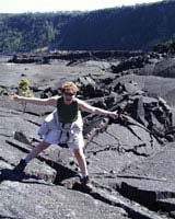
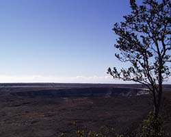 - A view from the top of
the volcano caldera
|
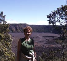 - A view from the Kilauea
Trail
- (We're on the rainforest
trail above the crater. The second half of
the loop trail crosses the crater floor
containing steam vents...
cool!)
|
- We checked into our room that evening
at the Volcano
Inn, located just outside the entrance
to Volcanoes
National Park. We stayed in the
Honu
(sea turtle) room. We loved it. Next
morning after a hearty breakfast at the
Inn of scrambled eggs, a hamburger patty
with rice and mushroom gravy, a fresh
papaya half, pineapple, and guava juice
(this was a Hawaiian menu - - it was very
good), we headed out for a day of
hiking.
-
- The Road
Guide we followed is available online.
We first drove the 11 mile loop drive
around the Kilauea Caldera - - a huge
volcano crater containing a series of
craters within it. There are several steam
vents indicating the molten heat that
exists an estimated 2 miles below the
surface, but you can hike several trails
through the Caldera. The Halemaumau Crater
is the home of Pele,
Goddess of Hawaiian volcanoes. There are
many legends about Pele and native people
still come to this site to make offerings.
When Mark
Twain visited there in the 1860s (He
was a journalist who had recently tired of
the gold fields of California and traveled
here to do a series of articles for the
San Francisco Union, Twain was not
well-known then as a writer), he looked
down into a sea of molten, fiery lava and
described it as looking like hell. It has
cooled down since then. But Twain's
observation was a reminder that this chain
of islands was and is still being shaped
by active volcanoes along with a little
added coral growth.
-
- After nearly circling around the
Caldera in the car, stopping to visit a
museum, shopping at an art gallery (we
bought a beautiful Koa
wood covered sketchbook), and exploring
the Volcano House (built on the crater rim
-- original was there when Twain visited),
we stopped to take a loop hike around the
north rim of the Kilauea Iki Crater and
then down and across it - this is a small
crater within the Kilauea Caldera - total
trip was over four miles. We traveled
through a rainforest along the rim, then
descended into the lava. There were still
a lot of rifts and steam vents that were
putting out scalding vapor. The climb back
out to the parking lot was steep and
strenuous, but Annette was working to get
Larry in better physical condition. This
was the first of several hikes that
day.
|
 -
- Next it was down the mountain on the
'Chain of Craters' road, still within the
national park, to the seashore to get as
close as we could (by car) to the lava
plume. Most of the 20 mile drive is
through or near lava beds. Near the shore
the dropoff from cliff to lower crests
gave views of successive flows that
spilled down to the sea. Down on the lower
shelf of land, we stopped to hike out on
old lava flows where native Hawaiians
pecked out petroglyphs.
-
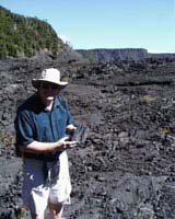
The easy, 2-mile, round-trip hike leads to
Pu'u Loa, the largest concentration of
petroglyphs (more than 15,000) in Hawaii.
What makes this area so interesting is its
purpose. Early Hawaiians from all over the
islands came by long canoe after the birth of
a child. It was their custom to bring the
umbilical stump (piko) of a newborn baby,
carve a hole in the rock, place the piko in
the hole, and cover it with a stone to assure
a long life. Some families use a circle
around the hole to indicate a family area of
multiple children and/or generations. The
tradition continued into the 1800s when
missionaries arrived and frowned on the
practice.
|
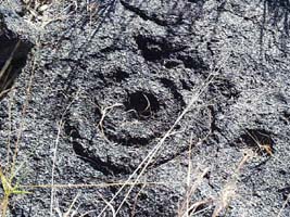 - A petroglpyh from the
Pu'u Loa site
|
 -
|
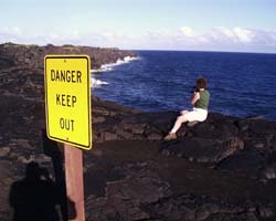
- We continued our drive on the 'chain
or craters' road along the coastline. We
stopped a couple times to videotape the
pounding surf, explore the Holei Sea Arch
from a distance, and watch the steam plume
rise several miles away. There were lots
of signs warning about the dangers of the
volcano, loose rock, and unstable cliffs.
Annette carefully crawled out to this very
'stable' point for a good shot of
surf.
-
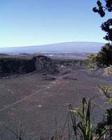
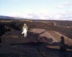
- Our final hike late in the day was at
the end of the road along the coastline
where recent lava flows had overrun the
park road on their way to the sea. The
visible steam plume was six miles away
across an intervening span of recent,
rough lava beds. We scrambled out over a
mile, hitting several locations where
sections of the roadway were still
visible. The lava here was rough and hard
to walk on because of the uneven footing.
It was also late afternoon, so visibility
was deteriorating. If we had come prepared
with more water and bigger flashlights, we
would have been tempted to hike in close
enough to see the glow of the lava tube
after dark. But this time, we heeded
caution and took a few pictures of the
rugged terrain, the isolated roadway
sections, and trekked back to our car.
Stopping at the temporary hut at the edge
of the lava, we talked to a ranger. She
told us of a couple in November, who
ventured out and got caught in the heavy
rains. When it rains, the lava is covered
in a dense fog because of the heat
contained in the porous rock. Rangers knew
they had someone out there at the end of
the day because there was one car setting
along the roadway, but with the deep fog,
they were unable to start a search until
the rain stopped and visibility cleared.
Two days later, the wet, tired couple were
found about a mile from their car.
-
- As the skies darkened we headed back
up the road to a meal at the Lava
Rock Cafe and then on to our room and
an early sleep. We had hiked over eight
miles of rugged terrain that day.
-
- More Information?
|
Created by Annette
Lamb and
Larry
Johnson,
12/00-
 - Return
to Trip Page
|