Middle Earth to Panem:
Maps as Invitations to Reading
I've been a map geek for more than 60 years. As a map geek, the first thing I do when I thumb through a book is look for maps. Is there a map on the end pages or maybe somewhere in the middle? I can still spend endless hours enjoying an atlas.
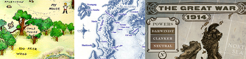
The books in our libraries are filled with maps. When you see a map of the Hundred Acre Wood from Winnie-the-Pooh, do memories of the bee tree and rabbit's house spring to mind? This fictional map is based on the Five Hundred Acre Wood that you can visit through Google Maps.
Maps in books provide the opportunity to address many 21st century skills including using online maps and satellite images, analyzing primary source documents, and constructing maps.
Visualize a real place through a fictional story. Maps of real places help young people better understand wars in particular regions of the world such as the conflict in Afghanistan through a map of the region found in The Breadwinner by Deborah Ellis.
Visualize an imaginary world. A map can help children visualize the imaginary world of a particular place such as Panem from The Hunger Games. However, in this case, fans have created the maps and shared them on websites such as Deviant Art. The original book didn't provide a map. It wasn't until the movie was released that an official map became available on Instagram. Also, check out PanemPropaganda. Check out book The Panem Companion for lots of other ideas.
Combine maps, math and imagination. Authors have unique relationships with the worlds they build. Tomi Adeyemi the author of the Legacy of Osrisha series created an imaginary map as she was building the world of Orisha.
I actually designed the map on this online program and it was really helpful to me, because its a big story and they go so many places and then I was trying to be like, 'How long would it take to get from this village to this city, if horses ride this many miles per hour over the course of this, and this is the meters and we can superimpose that on how fast a lion runs,' and I would do all this math. Tomi Adeyemi, Cosmopolitan
This presentation is intended to help librarian, educators, and parents connect maps to reading, teaching, learning, and libraries. Let's explore the following areas:
- Book Maps for Youth: A History
- Map-Story Connections
- Types of of Book Maps
- Ways for Locating Book Maps
- Real World Maps
- Historical Maps
- Imaginary World Maps
- AIdeas of Book Maps in Teaching and Learning
- Ideas for Building Maps
- Ways to Promote a Passion for Maps
Book Maps for Youth: A History
Books for youth haven't always included maps.
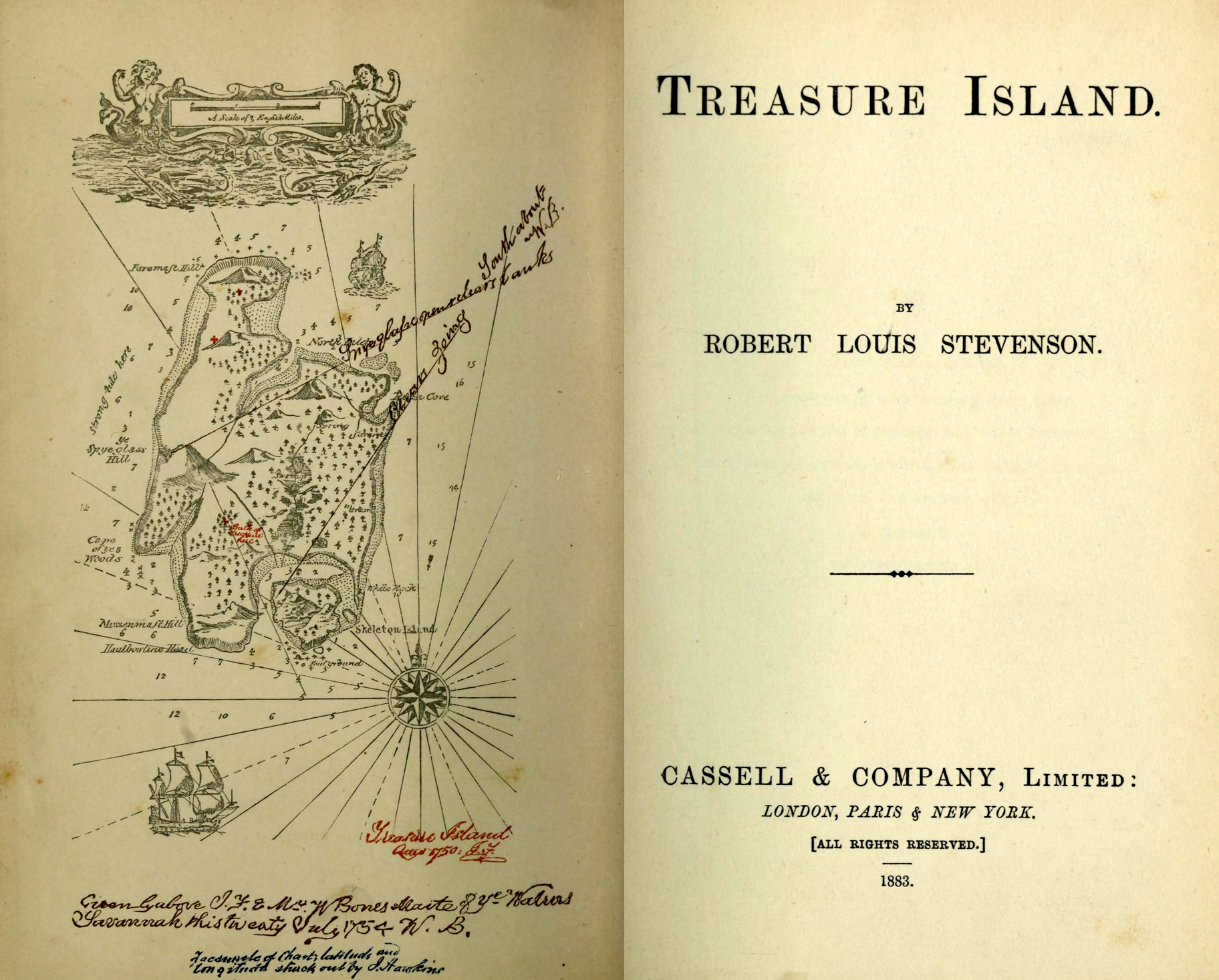
- Treasure Island (1883) (Map) by Robert Louis Stevenson contains one of the first books for youth with a map. Because maps in books are often on the endpapers, they are sometimes lost in paperback and e-book editions.
- Some authors like Arthur Ransome became known for their book maps (Maps).
- The Hobbit (1937) contains a map that is referred to many times in the text.
- Maps grew in popularity in the 20th century.
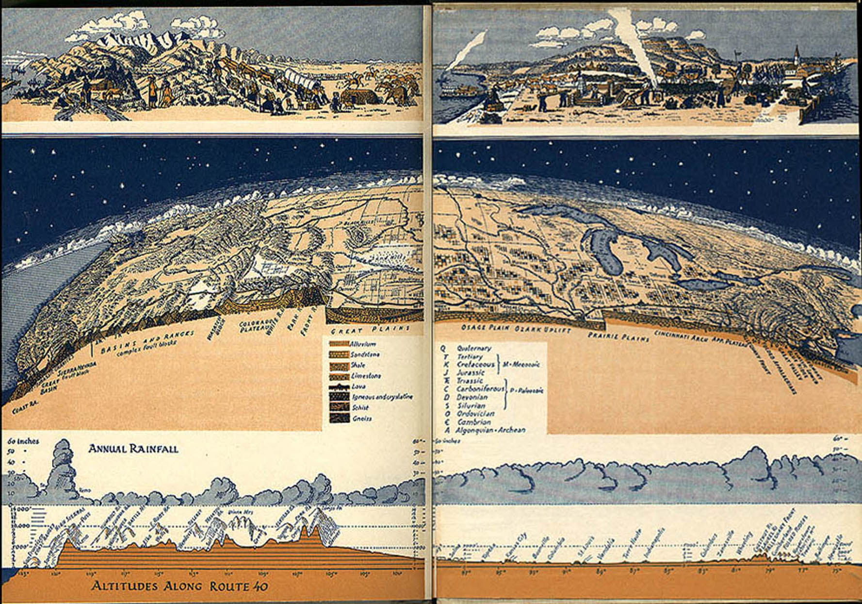
- Maps often appear in works of nonfiction. For instance U.S. 40: Cross Section of the United States of America is a book that explores this famous road. U.S. 40: Cross Section of the United States of America (1953) (Map) by George R. Stewart
- The I Spy Annual (1954) is an example of a pirate map (Map) appearing on the endpapers.
- In the Expeditioners by S.S. Taylor series, a beautifully designed map is woven directly into the storyline. Three siblings go off in search of unmapped lands that arent on the old computer-generated maps. Use this idea of unmapped areas to challenge youth to investigate places that are censored on Google Maps. Some areas are blurred out or distorted for security reasons, while others may simply be errors. A simple Google search for censored Google Maps yields lots of interesting results for students to ponder. Or, go directly to the list at Wikipedia. Unfortunately, the map is in the endpaper, so it's lost in the e-book and paperback versions.
- The popularity of endpaper maps continues today with books like Cast Away on the Letter A and The Wild Piano.
Map-Story Connections
Sometimes fantasy inspires reality and in other cases reality impact fantasy. For instance, an interactive climate change map like Surging Seas inspired Marie Lu's world building in Legend. Maps are often used in different ways based on the genre:
- Picture Books. In picture books, maps provide simple, visual cues to geographic locations. Over on a Mountain by Marianne Berkes is an example.
- Mysteries. In a mystery, a map might be used to show clues, illustrate event locations, or track the movement of characters. It might be used by the reader to solve the mystery. Chasing Vermeer and The Calder Game by Blue Balliett and illustrations by Brett Helquist are examples.
- Adventures. In an adventure, a map might be used by readers to track a series of events, actions, or steps in the story. The Wind and the Willows is an adventure set in a rural area.
- Historical Fiction. In historical fiction, a map might be used to show the location at a particular point in time. Readers might following a real battle or the plights of characters on the underground railroad. The map might help explain historical events like why was Denmark important to the Nazis? The Boys Who Challenged Hitler by Phillip Hoose is an example.
- Realistic Fiction. In realistic fiction, a map might show how fictional character move and interact with places in the real world. Wild Man Island by Will Hobbs takes place on Alaska’s A-B-C islands of Admiralty-Baranof-Chichagof. The book provides a map with the key locations. Google Images is a quick way to locate additional maps that have useful information about the vegetation, topography, and other details. Do a Google search for Admiralty-Baranof-Chichagof map.
- Fantasy Fiction. In fantasy, a map can be used to track character movements. Dragon Keeper by Carole Wilkinson is an example. Sometimes fantasies incorporate geographical elements from the real-world such as the Yellow River and the Great Wall.
- Speculative Fiction. In speculative fiction, a map might show an alternative universe and help readers visualize differences from reality. Leviathan by Scott Westerfeld is an example. Use maps to discuss fantasy versus reality elements of the story in a book.
- Comics and Graphic Novels. In comics and graphic novels, maps are often used as part of the visual storytelling process tracing the path of characters. Theseus and the Minotaur by Yvan Pommaux is an example.
- Multiple Maps. Some books provide multiple maps demonstrating different points of view. For instance in the Seekers series by Erin Hunter. Readers see both the Human's View and the Bear's View.
- World View. Some maps change how readers view a world they thought they knew. For instance, Wicked by Gregory Macguire re-imagines the land of Oz.
- Expanded View. Some authors provide maps that extend the world to include information for an entire series. Brian Jacques' Redwall Map is an example. It's contains a full-sized map of the Redwall world. Another example is the Star Wars world with books like Star Wars: Complete Locations, Star Wars: The Essential Atlas, Star Wars: Galactic Maps, and others. Do a Google Search for the book series and add the word "map" for many more ideas.
- Wiki Worlds. Some imaginary worlds have expanded enough to have their own wikis and supplemental materials to go with the map and other book materials. Dinotopia is an example.
Types of Book Maps
- Town Map. Sweet Pickles books are known for their bright pages. The back endpaper includes a map of the town.
- National Park Map. In The Maze by Will Hobbs, a map shows the Maze District of Canyonlands National Park. The map provides a nice overview of key locations associated with the book. However, a visit to the Canyonlands National Park website provides more in-depth maps, distance information, and useful facts about Canyonlands.
- World Region Map. Shabanu by Suzanne Fisher Staples contains a map showing a particular region of the world.
- Historical Map. Mr. Tucket by Gary Paulsen is set in the mid-19th century and contains a map of the United States showing locations during that time including historical trails.
- Map with Inset. Graceling by Kristin Cashore shows a map of an imaginary kingdom with an inset of a specific area. Involve youth in creating insets for their imaginary or real-world maps.
- Imaginary Place Map. The Spiderwick Chronicles by Tony DiTerlizzi and Holly Black contains an imaginary estate map.
- Journey Path Map. The Long Walk to Water tells a true story and shows the journey on the map.
- Subway Maps. Lost in NYC by Nadja Spiegelman & Sergio García Sánchez weaves subway maps into a graphic novel. The end papers contain a map of the whole system and other maps serve as background.
- Star Map. The Copernicus Legacy by Tony Abbott includes a 17th century inspired astronomical star map from Copernicus's time. It can be downloaded along with a teaching guide.
- City Cross Section. Gabriel Finley and the Raven’s Riddle by George Hagen shows a cross section of the imaginary world under New York City.
- Building Cross Section. The Case of the Stolen Sixpence by Holly Webb contains a cross section of a house.
- Maps that Mix Reality & Fantasy. The Sea of Trolls by Nancy Farmer contains a map that mixes fantasy with reality.
Ideas for Locating Book Maps
- By Author. Use the author's website to locate maps from the book and extended experiences. Read about how Christopher Paolini designed the Map of Alagaësia.
- By Illustrator. Do a Google search for a children's illustration. Then, search the site for examples of maps. For instance, children's author and illustrator Jennifer Thermes provides a page featuring her book maps. She has many maps to explore.
- By Series. Use the book's series website to locate maps from the books such as The Warriors by Erin Hunter.
- By Publisher. Use the publisher's website to locate maps from the book such as Three Times Lucky and The Ghosts of Tupelo Landing by Sheila Turnage.
- By Digital Collection. Use Archive.org to locate maps in book that are in the public domain. The Swiss Family Robinson by Johann David Wyss is an example. HathiTrust is another good source for books such as Tik-Tok of Oz by L. Frank Baum showing the first map of Oz.
- By Book Preview: Google Books Preview. Search Google Books. Take a screen capture of the map such as The Tapper Twins series by Geoff Rodkey.
- By Book Preview: Barnes and Noble Preview. Search the Barnes and Noble website. Take a screen capture of the map such as The Extraordinary Adventures of Ordinary Boy by William Boniface.
- By Book Preview: Amazon Preview. Search Amazon to locate previews with maps. Take a screen capture to get the image such as Unlikely Warrior: A Jewish Soldier in Hitler's Army by Georg Rauch.
- By Google Images. Use Google Images to search for a book map. Use Razorhurst by Justine Larbalestier as an example.
- By Scanner. Use a scanner to scan the map you wish to use. In some cases you'll need to piece the map together such as The Family Romanov by Candace Fleming.
- By Camera. A digital camera on a copystand works best for creating your own images, however even a cell phone camera will work. For instance, In the New World by Christa Holtei contains a color map that can be photographed for use.
- By Document Camera. Place the book on the document camera stand to take a picture. However, also consider using this approach for enlarging the map to create a wall-sized version for your library. An old-fashioned overhead projector or opaque projector will work too!
Real-world Maps
Many works of fiction for youth are set in real locations around the world. In many cases, the authors of these books have provided maps to help readers better understand the setting of the story. These maps provide an important starting point for exploration of the book’s setting along with insights into the characters and plot. Many works of narrative nonfiction contain useful maps too.
- Each book in the Travels with Gannon & Wyatt series by Patti Wheeler and Keith Hemstreet focuses on a different area of the world including Botswana, Greenland, Egypt, and the Great Bear Rainforest. Based on the experiences of real-life teens, the maps help connect the fictional adventures to real places. Readers can even go online and examine authentic photos and videos to learn more about the exotic book locations.
- Like NERDS, The Genius Files: Mission Unstoppable by Dan Gutman encourages youth to use online tools like Google Maps as they read the book. From locating West Marin Middle School in Point Reyes Station, California to the National Mustard Museum in Middle, Wisconsin, readers are treated to a wide range of interesting locations in this cross-country adventure.
- At the beginning of each chapter in NERDS by Michael Buckley, the author prints latitude and longitude coordinates that youth can enter into Google Maps to identify specific locations. Using Google Street View , readers can even see through the eyes of characters as they walk down the street.
- Compare fictional maps to real areas of the world to bring the places alive. For instance, Arthur: The Seeing Stone by Kevin Crossley-Holland provides a map. Look for historical photos and recreations to visualize the elements of the manor.
- Many of today’s most popular informational books convey content through a compelling scientific, cultural, or historical maps.
Many of the Magic Tree House books by Mary Pope Osborne now come with a companion book that contains maps cooresponding to the location of the story. For instance, Fact Tracker: Rain Forests is the companion to Afternoon on the Amazon. It contains a map of rainforests around the world. - Passenger on the Pearl by Winifred Conkling tells the true story of Emily Edmonson’s flight from slavery. The nonfiction book includes maps showing the escape route of those slaves leaving on the Pearl and the routes of slaves sold to the South during what is known as the Second Middle Passage. Pair this work of nonfiction with fictional accounts of slave escape attempts. Online maps can be used to highlight specific aspects of slavery and the Underground Railroad. The US Slave Animation map shows slave and free states between 1789 and 1861, and the Compare Two Worlds map shows what was happening in the North versus the South. Extend the discussion with an exploration of other Underground Railroad escape attempts. The National Park Service Underground Railroad Map provides a map showing hundreds of locations related to the Underground Railroad.
- Unbroken by Laura Hillenbrand is a young adult adaptation of the bestselling book about Olympic runner Louie Zamperinis experience as a castaway and captive during World War II. A map of the Pacific Ocean provides an overview of the setting for this engaging, true story. Ask students to investigate another individual and use TripLine to visualize their story on a timeline map.
- Plastic Ahoy! Investigating the Great Pacific Garbage Patch by Patricia Newman tells the story of scientists investigating the huge cluster of plastic debris in the Pacific Ocean. A map of the region in the book shows the ocean currents and debris. NOAA’s Marine Debris shows a similar view of these patterns. Do a Google Images search to locate dozens of infographics containing maps such as the one at Visual.ly. Ask students to pick the visual that they think best represents the problem and explain why.
- The Case of the Vanishing Little Brown Bats: A Scientific Mystery (2015) by Sandra Markle includes a map of the eastern half of the United States showing the areas with bats affected by White-Nose Syndrome. Involve youth in seeking out maps and information from specific states. Ask students to compare the data from the book’s map with what they find. Also, involve then in tracing the changes over time. The White-Nose Syndrome website posts updated maps every few months.
- The Polar Bear Scientists by Peter Lourie from the Smithsonian Scientists in the Field series follows biologists as they track polar bears to learn more about global warming. The Bear Tracker website contains an interactive map where youth can follow bears in close to real-time. Use maps suggested by the book.
- Increasingly, books for youth are incorporating maps and satellite images. The Skull in the Rock by Lee R. Berger and Marc Aronson incorporates maps and labeled images from Google Earth.
Historical Maps
Many works of historical fiction contain maps.
- Ghost Hawk by Susan Copper is set in 17th century New England. Involve youth in learning to use digital collections to find maps of particular time periods such as those from OsherMaps.
- Rather than exploring the entire world, the map in Jason’s Gold by Will Hobbs focuses on the Pacific Northwest in 1897 associated with the Klondike gold rush. The map provides an overview, but lacks a feel for the historical aspects. The National Park Service maps can fill the gap between the general map in the book and the specific areas mentioned in the book including Seattle, Skagway, and the routes north. The David Rumsey Map Collection contains a great map published in 1898 showing routes north.
- Many maps serve scientific purposes. One of the most famous maps was produced by Dr. John Snow during London’s cholera epidemic. The Great Trouble: A Mystery of London, the Blue Death, and a Boy Called Eel is a work of historical fiction by Deborah Hopkinson. Focusing on London’s cholera epidemic, a map created by Dr. John Snow plays a critical role in identifying the cause of the epidemic. Use this book and map to jumpstart a discussion of the role maps can play in a wide range of scientific investigations. An interactive version of this map is available at The Guardian.
- Inspired by family stories, The Birchbark House by Louis Erdrich includes a hand drawn map containing an overview of the local community in 1847 along with a map of present day northern Minnesota. Use the Ojibwe People’s Dictionary to associate historical photos such as the dwellings with the icons used on the map. Also, look at how Indian lands changed after this story took place at The Invasion of America.
- The Bomb by Theodore Taylor contains a map of the Bikini Atoll in the Western Pacific Ocean. However, an even more interesting map of the BRAVO Test Fallout Pattern helps reader understand the impact of the bomb on islanders.
- While many fiction books for children and young adults contain maps, others focus on specific locations but don’t include maps or other visuals to help youth envision the setting. For instance, Moon Over Manifest by Clare Vanderpool is set in Missouri during the Depression. HistoryPin is another project that matches locations with historical images.
- Rodzina by Karen Cushman follows a twelve-year-old girl as she travels west on the orphan train in 1881. Use old railroad maps to trace her path across the United States as she travels through Illinois, Iowa, Nebraska, Wyoming, Utah, and Nevada to California chapter by chapter. The Library of Congress Railroad Maps, 1828-1900 collection contains dozens of maps for youth to explore. Discuss what map would be best for identifying the railroad lines in 1881. Help youth use the search tools. Ask them to select and defend their choice of a map that would be most useful in tracking Rodzina’s way west such as the 1875 Rand McNally & Co’s New Railroad and County Map.
- Military Path Map. Soldier's Heart by Gary Paulsen shows the path of the First Minnesota Volunteers during the Civil War. Many online, interactive maps including Civil War Animated can be used to help youth understand Civil War battles.
- Between Shades of Gray by Ruta Sepetys is set in 1941. Maps shows the route Lina and her family traveled from Lithuania to the North Pole during the course of the book. An accompanying timeline shows the day of the journey and their location. The United States Holocaust Memorial Museum (USHMM) provides a wealth of information and historical maps showing Lithuania and other locations from the time period. Rose Under Fire by Elizabeth Wein takes place at the Ravensbruck Concentration Camp. Readers can view maps of the camp at the USHMM.
When reading historical fiction, it can be helpful for students to use historical maps. This is particularly important with historical fiction where locations may have changed tremendously over time. For instance, the USGS Historical Topographic Maps allows users to overlay maps from the past with maps from the present for locations throughout the United States. For lots of other examples of how historical maps can be used in the classroom, go to Historic Maps in K-12and Library of Congress Map Collections.
Imaginary World Maps
Provide youth with a list of books with maps and a list of project options. Let them choose the combination.
- Inkheart series by Cornelia Funke. Add a journey path based on a book.
- Prydain books from Lloyd Alexander. Critique the map.
- Lavinia by Ursula K. Le Guin. Identify elements of the map.
- The Young Elites by Marie Lu. Extend the universe. What's beyond the borders of the map?
- Dr. Critchlore's School for Minions by Sheila Grau. Write a scene set in one of the locations.
- Seraphina and Shadow Scale by Rachel Hartman. Create an inset map of an area.
- Sabriel, Lirael, and Abhorsen by Garth Nix. Locate character movement on the map.
- The Natural History of Dragons by Marie Brennan. Create a different type of map.
- Wings of Fire by Tui T Sutherland. Write a short story with new characters.
- Tricker’s Choice by Tamora Pierce. Built a diorama of the islands.
- Luck Uglies by Paul Durham. Create a floor plan of a building from a scene.
- Seaborne: The Lost Prince by Matt Myklusch. Create a treasure map for this world.
- Spirit Animals by varied authors. Invent your own spirit animal and place them in this world.
- The City of Ember by Jeanne DuPrau. What would characters say about the map?
- The Death of Yorik Mortwell by Stephen Messer. Title a new story an area of the map. Put the setting at the center of the story.
- The Earthsea Trilogy by Ursula K. LeGuin. What would happen if elements on the maps were different? How might it impact the story?
- Wildwood by Colin Meloy. Can you find a fantasy place in your town?
- The Secrets of Droon by Tony Abbott. Create an imaginary map, then create labels like the ones in Droon.
- The Witch Hunter by Virginia Boecker. The author adapted real places for her fantasy setting. For instance, she adapted the floorplan of a real palace. Choose a place and make your own adapted map.
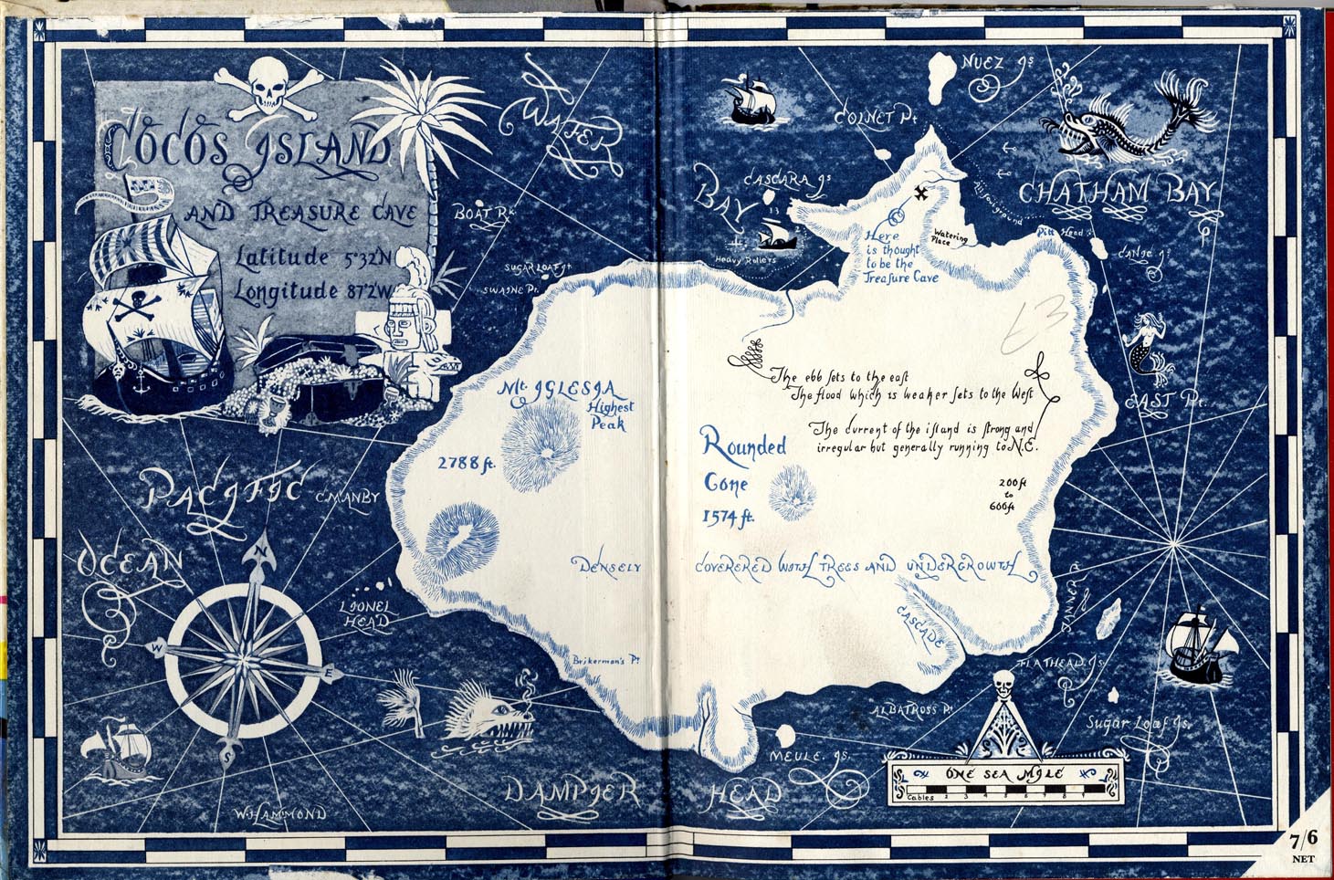
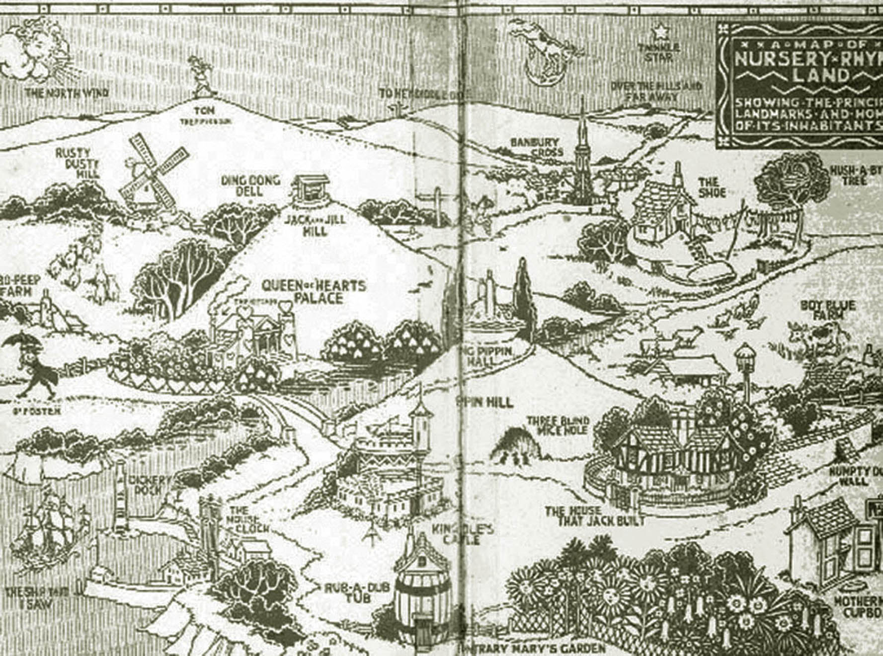
- Nursery Rhyme Land (1925) (Map). Create a map that combines your favorite story places.
- Harry Potter series by J.K. Rowling. These books didn't have maps. However, the author used a sketch for her writing activities. Many others have created their own vision of Hogwarts. Which fits best with your ideas? Examples: Hogwarts by Charles J. Mize, Wizard's Atlas.
- Lord of the Rings. Do a search for the title of a book and the word "interactive map" and you'll find cool online maps like Lord of the Rings: Interactive Map. The website provides access to an interactive map of Middle Earth along with timelines, places, paths, events, and other information.
Book Maps in Learning & Libraries
- Compare and Discuss. Fan maps can easily be found online. First, ask them to search for maps such as Warriors cat maps. Compare and discuss the maps. Ask students whether the maps reflect the books. Examples including Warrior Cats 1 by Erin Hunter and Warrior Cats 2. Each uses different tools and approaches.
- Compare to Satellite Images. Compare the map in a book to satellite images of the same area. Talk about the advantages and disadvantages of maps vs. satellite images. Discuss how they connect to understanding the text of the book. Many of Will Hobbs’s books contain maps. Never Say Die by Will Hobbs shows a map of Alaska along with the Yukon and Northwest Territories. Use topographical maps to bring the terrain of the area surrounding the Firth River to life. Download Topographical Maps of the region. Also, use an interactive map to learn about the types of scientific projects happening in Northern Canada. The USGS provides free topographical maps that can be downloaded in the PDF format.
- Follow Journey Path Map. A Girl Named Disaster by Nancy Farmer features a map of Africa showing the map of a character. A Girl Named Disaster by Nancy Farmer traces Nhamo’s Journey from Mozambique to Zimbabwe to escape an unwanted marriage. The book’s maps provide an overview of the continent along with the two countries. Google Earth would be useful in providing an overview of the area, along with the ability to zoom in on details such as the rivers and lakes.
- Read and Create Path Maps. Involve students in reading path maps. Then, ask students read a book or series, ask them to create a path map that shows the movement of characters such as Red Pyramid.
- Draw from Character's Perspective. The map in My Side of the Mountain by George Craighead George was drawn of Sam's perspective. Read any book and create a map from the perspective of a character.
- Compare to Period Maps. Compare the map in a book to authentic, historical period maps. Discuss why the specific features were selected for the book's map. Indian Captive: The Story of Mary Jemison by Lois Lenski contains a picture map of the Seneca Indian lands of the Genesee River Valley between 1758-1760. Ask students to compare a Historical Map to the drawing in the book.
- Compare Alternative History. Compare the steampunk genre map in Boneshaker by Cherie Priest to historical maps of the same time period. Create your own alternative map.
- Build Island Maps. An island is a common book setting. Maps of islands like Nim's Island by Wendy Orr are fun for youth to create, discuss, and storytell around.
- Follow an Event. Like Will Hobbs, Gary Paulsen is also known for his books about Alaska. Woodsong by Gary Paulsen contains a map of Alaska focusing on the Iditarod sled dog race. The Official Race map is a great way to help youth explore concepts related to distance through the sled dog race.
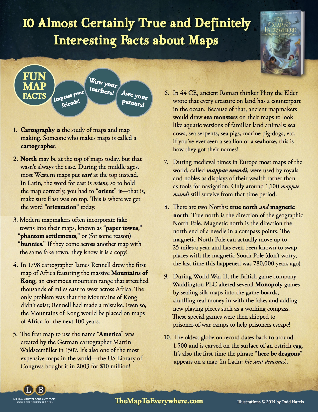
- Use Online Teaching Resource. Search for teacher guides to go with books. The Map to Everywhere website contains a fact-sheet librarians can download to learn more about maps.
- The Hank the Cowdog (by John R. Erickson) website contains a printable map showing the setting for the book.
Ideas for Building Maps
There are many traditional and emerging tools for map making.
- Label Maps. Explore The Booklovers Map of America (1926). Use Thinglink to create your own. For example, The Fourteenth Goldfish by Jennifer L. Holm. The Imaginary Veterinary Series by Suzanne Selfors is set in the imaginary town of Buttonville. Copy the Buttonville map and place it in PowerPoint. Then, add autoshape labels. Check out a child's project based on the map in The Phantom Tollbooth by Norton Juster.
- Locate Maps. The Kingdom of Wrenly map can be downloaded from the series website. Then, it can be expanded, modified, or labeled.
- Use Traditional Tools. Take ideas from various books about the same place to create your own map. For instance, the Neverland Map combined ideas from the Peter Pan books and movies using traditional tools. Use crayons such as The Great Gatsby to map a city. and colored pencils such as Camp Half-Blood to to map a scene.
- Use Technology Tools. Use whatever software you have available.
- Paint Tools. Involve youth in designing their own island. Focus on terms associated with land forms such as archipelago, cape, cliff, estuary, isthmus, waterfall, and peninsula. This is a great opportunity to practice using painting and drawing tools. Online tools like Sumo Paint work well for designing an island. Use paint tools to visualize any book such as Lord of the Flies.
- Enhance an Original. Ask youth to select a map from a book and create their own modified version. For instance, check out a colored version Alagesia from Eragon.
- Random City Generator. The Random City Map Generator is a tool students can use to create a randomly generated city or town that can be used for their own story.
- Online Island Generator. The online Polygon Map Generation tool can be used to create generate your own island. Users can choose their islands shape, points, and views. For lots of ideas, read Fantasy Mapmaker by Jared Blando.
- Creature Creator. My Father's Dragon by Ruth Stiles Gannett is full of interesting icons representing the flora and fauna of the islands. Students enjoy adding these types of symbols to their maps. The 1949 Newbery Honor book My Father’s Dragon by Ruth Stiles Gannett is now in the public domain and available online. The endpapers contain a beautiful illustration of the Island of Tangerina and Wild Island. The map is filled with interesting real and fictional creatures. Involve youth in drawing their own island and filling it with their own imaginary creatures. Do a Google search for creature creator for many other online tools.
- Fantasy Map Software. Both open source and propriety software are available for creating fantasy maps. AutoREALM is a popular tool for creating maps of cities, castle, caves, and other fantasy elements. For high quality commercial software to create worlds, cities, and other types of imaginary places, try Pro Fantasy Software.
- Share Maps. The social network DeviantArt is a popular way to share artwork. Many youth create their own interpretation of worlds such as Harry Potter, The Hunger Games, and the Divergent books that don't contain maps.
Ways to Promote a Passion for Maps
Use books to promote an interest in visual literature and maps. Start by searching your own library for books with maps.
- Start Young! Connect books, maps, and music to get young children interested in maps like those in Dora the Explorer books.
- Point Out Maps. Maps can be found in many popular books. Point them out to readers and encourage them to seek out maps. For instance, there's a map in Timmy Failure: Mistakes Were Made by Stephan Pastis.
- Connect Books with Maps to TV and Movies. Shadow and Bone's popularity surged with the Netflix adaptation.
- Focus on Adventure. Each book in the National Park mystery series by Gloria Skurzynski and Alane Ferguson focuses on a different national park. Excellent maps show the location of the park in the United States along with a detailed map of the park. The National Park Service is known for their quality maps for each national park. The Adventures with the Parkers series by Mike Graf incorporate the official National Park Service maps into their books. Use the Find A Park interactive map to locate parks by name, location, activity, and topic.
- Connect with Outdoor Experiences. Use books with maps as inspiration for your own stories and maps.
- Think Local! If you near Alcatraz, read books set on this famous island. The Al Capone at Alcatraz website is a companion to the Tales of Alcatraz books by Gennifer Choldenko. Check out National Park Service Alcatraz maps.
- Encourage Mapmaking. Encourage mapmaking through reading books such as The Map Trap by Andrew Clement (teacher resources).
- Seek out Picture Books with Maps. Books like Henry's Map by David Elliot explore the usefulness of maps for young children.
- Focus on Fantasy Map Makers. The Glass Sentence by S.E. Grove from the Mapmakers series focuses on a mapmaker in an alternative universe. Set in an alternative 1891 where continents have been flung into different time periods, thirteen-year-old Sophia Tims must travel into uncharted lands in search of her kidnapped uncle. In this series, mapmaking has become a fine art including elements of science and magic. Readers can download copies of the maps at the series website.
- Immerse Readers. The MapMaker Chronicles is a series by Australian author A.L. Tait.
- Read Maps. Encourage youth to use maps for orientation and visualizing a setting.
- Connect Maps. Connect the map to the plot, characters, and setting of the book.
- Seek Books with Map Connections. Below are some examples:
Atlas of Imaginary Places
Cinemaps
Dictionary of Imaginary Places
Literary Landscapes
Literary Wonderlands
Once Upon a Time Map Book
Plotted
Writer's Map - Analyze Maps. Use maps to think about the spatial events of the story.
- Seek Out Master World Builders. Some authors such as Marie Lu are master world builders. Use their books as inspiration.
- Imagine with Maps. Encourage youth to think beyond the book and imagine their own stories based on the map.
- Geek Out with Kids. Use the books to jumpstart interest in maps:
Charting the World by Richard Panchyk
Children's Illustrated Atlas by Smithsonian
Follow that Map by Scot Ritchie
Manhattan: Mapping the Story of an Island by Jennifer Thermes
Maps by Akesandra Mizielinska and Daniel Mizielinski
Me on the Map by Joan Sweeney
The Road to There by Val Ross
World Atlas by National Geographic for Kids
- Geek Out. If you're a fan of maps, check out some of these great nonfiction works for adults:
Great Maps by Jerry Brotton
How to Lie with Maps by Mark Monomonier
Mapmaking with Children by David Sobel
Mapping it Out
Maps: Finding Our Place in the World
Maps of the Imagination: The Writer as Cartographer by Peter Turchi
On the Map by Simon Garfield
Pictorial Maps by Nigel Holmes
The Phanton Atlas by Edward Brooke-Hitching
You Are Here by Katherine Harmon