Imaginary Locations from Middle Earth to Panem:
Maps as Invitations to Reading
While A. A. Milne brought the Hundred Acre Wood alive for children through a pictorial map, J.R.R. Tolkien used a map in Lord of the Rings to help readers follow the adventures in Middle Earth. Padron states that
“not only do (maps) allow us to picture places and spaces, but by telling stories that take place in them, or by sculpting characters associated with them, they give those places life and meaning” (Padron, 2007, 258).
The History of Maps in Literature for Youth
 Today, maps play a central role in many fantasy works for children and young adults. However, the use of maps to excite and assist readers is a relatively recent invention (Brogan, 2004). Books like Robinson Crusoe didn’t contain maps. It wasn’t until the late 19th century that maps were introduced in works for youth.
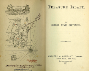
One of the first maps in a book often read by youth was Treasure Island by Robert Louis Stevenson. Unfortunately, the map has been removed from many subsequent versions. Because maps are often placed on the endpapers of books, they may be missing in paperback editions.
Use online book archives sites to seek out these missing maps. For instance, it’s possible to find different versions of Treasure Island with different at Archive.org including an 1883 edition.
L. Frank Baum drew dozens of maps of Oz, but the first published map appeared in the endpapers of Tik Tok of Oz by L. Frank Baum. Since there are very few original print copies of the book around, the Internet is an easy way to locate the maps of the Land of Oz. Some imaginary worlds have been “reimagined”. The Land of Oz was reimagined by Gregory Maguire in a map from his book.
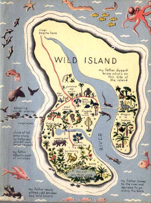
The 1949 Newbery Honor book My Father’s Dragon by Ruth Stiles Gannett is now in the public domain and available online. The endpapers contain a beautiful illustration of the Island of Tangerina and Wild Island. The map is filled with interesting real and fictional creatures.
Imaginary Worlds
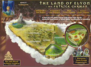
Like the map of Middle Earth found in The Lord of the Rings, many books for children and young adults incorporate entire imaginary worlds. Some book series websites even provide interactive maps that expand on the maps provided in the books. Examples include The Inheritance Cycle by Christopher Paolini and The Land of Elyon series by Patrick Carman.
In the Expeditioners by S.S. Taylor series, a beautifully designed map is woven directly into the storyline. Three siblings go off in search of unmapped lands that aren’t on the “old” computer-generated maps. Use this idea of “unmapped areas” to challenge youth to investigate places that are censored on Google Maps. Some areas are blurred out or distorted for security reasons, while others may simply be errors. A simple Google search for “censored Google Maps” yields lots of interesting results for students to ponder.
Other great books with maps of imaginary worlds include The Earthsea Trilogy by Ursula K. LeGuin, The City of Ember by Jeanne DuPrau, Tricker’s Choice by Tamora Pierce, and The Princess Bride by William Goldman.
The map in Nim’s Island by Wendy Orr is an imaginary island in the South Pacific.
Although the Harry Potter books don’t contain map illustrations, the Pottermore companion site uses an interactive map to guide participants through the world of Harry Potter.
The Marauder’s Map from Harry Potter is a different type of interactive map. However it’s a magical document that can only be read by wizards. Use the Harry Potter Wikia page to explore this map as well as learn more about wikis and collaborative writing communities. Think about ways students could use wikis to share their excitement about book maps.
Imaginary Places based on the Real World
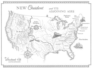 Many authors for youth build entirely new worlds for their characters, others incorporate alternative versions of our own universe. For instance, the new fantasy series Mapmakers by S.E. Grove contains maps with familiar geographic features. Set in an alternative 1891 where continents have been flung into different time periods, thirteen-year-old Sophia Tims must travel into uncharted lands in search of her kidnapped uncle. In this series, mapmaking has become a fine art including elements of science and magic. Readers can download copies of the maps at the series website.
While some books explore entire worlds, others focus on smaller areas like villages and towns. Three Times Lucky and The Ghosts of Tupelo Landing by Sheila Turnage contains a map that shows the fictional town of Tupelo Landing in North Carolina.
The park in the Elliot’s Park series by Patrick Carman is based on a real park. Readers can examine the book’s park illustration, then watch a video that contains photos of the real park.
Mixing reality with fantasy is particularly popular with speculative fiction, alternative histories, and steampunk works.
Some works of fantasy incorporate real cities and other places into their maps to provide a connection between a real place and the imaginary world. The Wind in the Willows by Kenneth Grahame is a map that combines reality and fantasy elements along the River Thames. In Wildwood, author Colin Meloy uses the “wilderness” area of Forest Park in Portland Oregon as the inspiration for an entire imaginary world.
Gabriel Finley and the Raven’s Riddle by George Hagen contains a pictorial map of Brooklyn and Manhattan along with the fictional city of Aviopolis deep underground. Youth enjoy exploring pictorial maps of both real and imaginary places. The world that Hagen envisioned bridges these two worlds. Do a Google search for pictorial maps of Manhattan and compare them to Hagen’s version. Ask students to create a pictorial map with fantasy elements of their favorite city. Rather than producing it from scratch, consider modifying an existing pictorial map.
My Side of the Mountain by Jean Craighead George provides an example of a pictorial map. It provides a labeled image drawn by the main character, Sam, of a fictional place near Delhi, New York. Ask youth to locate photographs taken near this area and match the images to the book’s map.
Imaginary Maps with Historical Connections
 Many books incorporate maps based on real places with a historical twist. In some cases the ties to real locations are strong. In others, they are based on mythology or alternative histories.
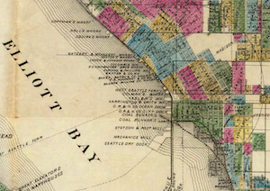
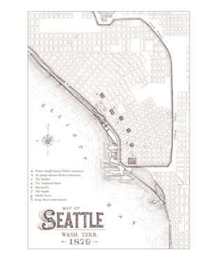
Some series like The Clockwork Century provide an alternative version of a real place. In Cherie Priest’s alternative Seattle, the 1879 map (right) shows a wall to keep out zombies. Compare this map with an actual historical map from the same time period from the David Rumsey Collection (below) overlaid on today’s satellite image of Seattle. Involve students in thinking about the modified map. What elements of the map have been changed for the fantasy book? Why did the author make these decisions? How does the map reflect the story’s plot.
Sea of Trolls series by Nancy Farmer builds elements of Norse mythology into a map that includes real locations. Do a Google search for Morse mythology maps for lots of examples to compare to the book’s map. Involve youth in creating their own Norse maps and diagrams of the cosmic ash tree and nine worlds.
The Arthur Trilogy by Kevin Crossley-Holland is set in 1199 and includes both a manor map and an area map. Although based on real locations, the book is a work of fantasy. An online interactive map allows visitors to explore castles all over the United Kingdom including Stokesay Castle referred by the book’s author.
Scott Westerfeld’s Leviathan series is set in an alternate 1914. The book’s endpapers include a stunning, allegorical map of World War I era Europe. During this time period, picture-rich political maps were used as propaganda campaigns. Many examples of these types of maps are available at Satirical World War One Maps. Ask youth to compare the book’s map with the historical maps from the time period.
Maps and Libraries
Librarians can use the maps found in popular books for children and young adults to jumpstart 21st century skills related to analyzing primary sources, using online map and satellite image resources, and constructing maps. The Standards for the 21st Century Learner stress the importance of understanding text in all formats including maps.
Maps play a supporting role in some books for youth. In others, the maps are an integral part of the storyline. In a study of children’s books, Jeffrey Patton and Nancy Ryckman (1990) identified a continuum of purposes for maps from simple to complex. At one end of the spectrum, maps were used to simply illustrate the general setting of the book. At the intermediate point, maps illustrated where the story occurred or how characters were connected to a setting. At the complex end of the continuum, the map served to explain or communicate spatial elements of the storyline such as illustrating a character’s journey or providing clues in a mystery.
Regardless of the author’s approach, book maps can be exciting tools in teaching, learning, and promoting the joy of reading.
Resources
Brogan, Hugh (2004). The lure of maps in Arthur Ransome. In K. Harmon, You Are There. Princeton Architectural Press.
Padron, Ricardo (2007). Mapping imaginary worlds. In J.R. Akerman and R.W. Karrow, Maps: Finding Our Place in the World. The University of Chicago Press.
Patton, Jeffrey C. & Ryckman, Nancy B. (Summer 1990). Maps in children’s literature. Cartographic Perspectives, 6-12.
Sobel, David (1998). Mapmaking with Children. Heinemann.
Lamb, Annette & Callison, Daniel (2012). Graphic Inquiry. Libraries Unlimited.


